
Tracing an Owasso Street Directory
An address trail should move from place to record, not from a broad name to an assumption. The Owasso street directory begins by preserving the printed address and checking whether the parcel lies in Tulsa or Rogers County. City GIS adds city-limit, fenceline, zoning, road, and neighborhood context. The county assessor then links the place to an account, parcel, legal description, owner index, and mailing-address field. Use those property identifiers to find the recorded document held by the County Clerk. Each source answers a different address question.
- Write the modern address exactly as supplied, including directional terms, ZIP, and any subdivision or unit detail.
- Check the City GeoViewer and the county parcel map to distinguish city status from county custody.
- Search the proper assessor with a minimal street number and name, then save the situs address, account or parcel number, and legal description.
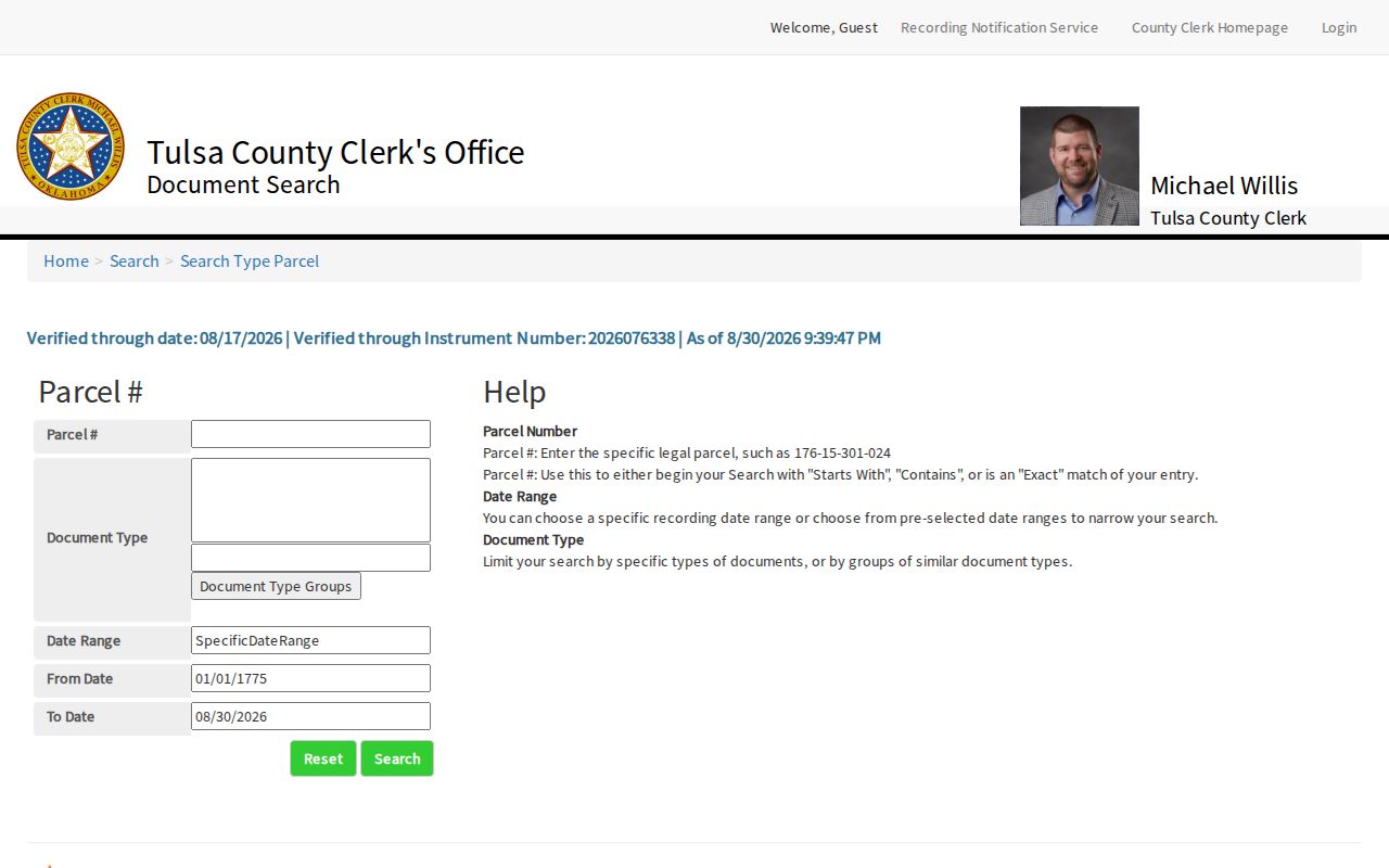
- Use the parcel or legal description in the Clerk index. On Tulsa parcels, Acclaim can narrow a parcel search by document type and date range.
- For an earlier period, search the street form in directories, newspapers, maps, permits, planning packets, and cemetery records, then compare the date on each entry.
Voter information is not a street-browse tool. The official portal uses name, first name, and date of birth for a registration service, and fuller voter-list access has eligibility and purpose rules.
Note: A parcel owner, a historical directory entry, and a current resident are separate labels that should not be collapsed.
Owasso Street Directory Boundary Check
Before using an Owasso street directory result, test the address against the local layers that look similar but mean different things. The city fenceline is approximately N Memorial Road to N 241st E Avenue and E 66th to E 126th Street North. It is a planning boundary, not an incorporated-city boundary. A property inside the fenceline but not annexed remains under Tulsa or Rogers County for county records. A USPS Owasso mailing city also does not prove city limits, school boundary, municipal-court jurisdiction, or the county that holds the parcel.
The City of Owasso City Maps page calls GIS the most current zoning source. Use it to orient a road, zoning layer, city limit, or neighborhood category. Then confirm land questions with the recorded plat, deed, or survey. Rogers Interactive GIS has a separate terms route and states that recorded plats and deeds control legal acreage and ownership. That distinction matters on the Rogers side of an Owasso street.
Owasso Street Directory Assessor Fields
The Tulsa County Assessor is the most detailed observed address index for the Tulsa side of Owasso. The property search accepts an address, account, subdivision, or owner, then provides column filters. Its guidance says less is more, and punctuation can interfere. Search a street number and name first. A matching card can supply a situs address, owner index, mailing address, account type, parcel, legal description, subdivision, school district, zoning, improvement details, value fields, and a sales/documents handoff.
| Search field | Type | Required | Observed Owasso use |
|---|---|---|---|
| Search scope | Selector | No | All was observed; result columns can be narrowed. |
| Address, account, subdivision, or owner | Text | No | Use short address text, a quoted subdivision, owner form, or account starting with R. |
| Column filters | Text controls | No | Use after the initial result to separate similar Owasso streets or names. |
| Search | Button | No | Runs the query. |
| Help, Load from Template, Clear | Controls | No | Show tips, retrieve a saved template, or reset the form. |
Rogers County has a different Assessor and GIS route. Exact online owner-search fields and an online cutoff were not located in the official research, so a Rogers-side address may require the Assessor, Interactive GIS, or Clerk counter rather than a presumed duplicate of the Tulsa tool.
Owasso Street Names and Numbers
Owasso street research has a local history rule: do not normalize away the old name. City subdivision regulations generally call north-south thoroughfares Avenues and east-west thoroughfares Streets. Numbering follows the Tulsa County system except in the original town area. Street extensions retain the established name, while new names or numbers need Planning Commission and City Council approval. The City Addressing Coordinator assigns lot numbers and street names, and a corner-lot address follows the main-structure frontage.
The original town-site plat was signed March 26, 1904. Its first north-south streets were Oklahoma, Kansas, and Missouri, while eight east-west streets used Union and Confederate general names. These names changed to current forms around 1960. An old deed, Ledger notice, or directory may therefore fail a present-day street search even when it concerns the same place. Search the source-era form and the modern cross-reference together, and retain the printed abbreviation such as av, st, r, or rms.
Note: Curving streets and cul-de-sacs in newer Owasso subdivisions may not follow the logic of the original town grid.
Owasso Records Searchable by Street
Address-keyed records provide a layered Owasso street directory rather than a list of every household. The assessor ties a situs address to an owner index and parcel. GIS shows spatial context. The Clerk holds the deed, mortgage, lien, easement, or plat. City material can show a permit, certificate of occupancy, code event, planning packet, or annexation process. Historical directories can place a named person at a street address in their own publication year. The records complement one another without proving the same fact.
| Address record | Address key | What it can show | Owasso access path |
|---|---|---|---|
| Assessor parcel card | Situs, parcel, legal description | Indexed owner, mailing address, improvement and tax clues | Tulsa or Rogers Assessor, office or request route. |
| GIS layer | Parcel, street, coordinate | Roads, parcel context, zoning, city limit, or fenceline | City GeoViewer or county GIS; reference map only. |
| Recorded instrument | Parcel, legal description, grantor or grantee | Transaction parties, document date, legal land description | Acclaim or the proper County Clerk. |
| Permit or certificate | Project or property address | Construction, use, or change-of-occupancy event | Monthly city lists and Community Development request. |
| Code or service record | Address and category | Notice, compliance, reinspection, or public-service event | RequestTracker category and department request. |
| Directory or criss-cross volume | Street and address as printed | Historical address or business connection | TCCL, OHS, and digitized directory collection. |
The parcel number creates the cleanest handoff from an assessor card to a recorded instrument. A street name is more flexible but also more prone to old-name, directional, and county-line errors. For a source-by-source list of a historic household, use the Owasso Directory Book after the address and date are known.
Owasso Deeds Along a Street
A property card is a useful doorway, but a recorded instrument is the land-record source. The Tulsa County Clerk's Acclaim system has search modes for name, document number, date range and document type, book and page, record date, consideration, subdivision or condo, section-township-range, parcel number, case number, and alpha index. County documentation reports name-index coverage from 1928 to current and legal-description coverage from 1987 to current. Those online coverage dates do not mean earlier paper, book, camera, or office records do not exist.
Name searching was account-gated in the observed Acclaim screen. Parcel searching exposes a different route: parcel number, document type, a date-range selector, From Date, and To Date. It supports starts-with, contains, and exact matching. Use the assessor account and legal description to avoid a weak name match. A record image is not automatically a certified copy or proof of current title, so ask the Clerk about certified copies when that status matters.
The Acclaim parcel-search screen is the source for this Owasso street directory step. Its document-type and date fields allow a parcel-led search without bypassing the account-gated name route.
For Rogers County, use the Clerk and GIS routes for that parcel and remember that the recorded plat or deed controls over a map display.
Owasso Street Directory City Records
City records add a public-process layer to an Owasso address. The City Archive can be searched by keyword, archive category, time period, and date range. A street, old street name, subdivision, ordinance, or applicant name can surface agendas, planning packets, minutes, or ordinances. Read the full packet rather than relying on a search-result title. Planning material can contain legal descriptions, plats, public notices, and owner or applicant information tied to a dated request.
Building inspections and permits are another address route. Owasso publishes monthly permit listings and requires a certificate of occupancy for new construction or a change in occupancy or use. The city says to use GIS to verify city limits. For a fuller address history, request existing permits by exact address and date range instead of assuming a monthly PDF is a complete archive. Code enforcement can show notice, compliance, reinspection, or abatement events, but private association disputes and some requester details are not the same as open city records.
Owasso Street History Before 1960
Street evidence becomes more useful when it is read as a dated record. The Owasso Ledger began in 1903, and a small surviving digital run includes 1904 and 1905 material. An issue can connect a street or town organization to a particular moment, but the run is incomplete. The City Archive is a searchable modern layer, while older city material may still be at City Hall or a department. County portals likewise sit alongside older books, camera images, and in-person materials.
Digitized Tulsa directories offer a second historical address path. The 1920 and 1921 scans include alphabetical and numerical or street sections. A printed entry can show a name, spouse marker, business connection, residence or boarding abbreviation, and street address. Search the literal historical spelling first, then expand carefully with a middle initial, spouse, street, subdivision, or county. A common surname needs parcel, date, or organization cross-checks.
Note: Record the created, filed, indexed, digitized, last-updated, and accessed dates separately when an Owasso street result crosses eras.
Owasso Address Terms
Four terms appear often in an Owasso street directory trail. They identify different parts of the record and help avoid a false match when an address, map, and deed use different labels.
- Parcel
- A defined piece of land identified through an assessor account, parcel number, or legal description.
- Situs address
- The physical location used on a property record. It can differ from an owner's tax mailing address.
- Plat
- A recorded map that depicts lots, blocks, streets, or easements. The recorded plat controls over a GIS reference display.
- Criss-cross directory
- A historical directory arranged by street and address, useful for locating a dated entry after the address is known.
A legal description, parcel number, and situs address should be saved together before a Clerk, GIS, or archive search moves to a different system.
Owasso Street Directory Limits
An Owasso street directory cannot establish every person connected with a street. An assessor card may show an indexed owner and a tax mailing address, not current occupancy. A directory entry is historical. City neighborhood maps show a boundary or organization type, not a private membership list. A voter service has protected data and is not an open block roster. Do not infer household composition from a deed, voter file, directory, business filing, or map category.
Oklahoma Open Records Act §24A.7 protects public-employee home addresses. The Address Confidentiality Program can protect eligible participants through a substitute address and restricted voter handling. Driver-license and state-ID data, Social Security numbers, protected victim addresses, and many sealed or juvenile records are not ordinary street-search material. If an official source is wrong, ask the custodian about correction or an explanatory note rather than combining conflicting records.
Owasso Streets as Dated Evidence
A well-kept street search file preserves the source rather than claiming more than it shows. Start with the exact address, county parcel, city status, and date. Add the assessor account and legal description. Then note the recorded instrument, archive packet, directory year, or map layer separately. This approach makes an Owasso street directory useful for family history, a public-process question, a property trail, or a neighborhood-history project without turning incomplete records into a present-tense resident list.
The most local detail is often the old street form. Compare the 1904 town grid, the approximately 1960 renaming, a current street label, and the county parcel. That small crosswalk can explain why a direct search misses a dated directory or newspaper record. It also keeps the Tulsa-Rogers line, postal city, and city boundary visible throughout the address trail.