
Owasso Previous Residents by Record Era
A backward address trail begins by matching the source to the period. Tulsa County's recorded-land indexes give a documented online path into later transfers. Libraries and archives preserve directory, newspaper, and census material that can add household context before or between transfers. Rogers County has a separate clerk and mapping route for the Rogers side of Owasso. The record shown in a table row is a research lead with a date range, not a promise that every owner or household appears online.
| Source | Years it covers | Where held | What it shows |
|---|---|---|---|
| Tulsa Acclaim name index | 1928-current, per county procurement material | Tulsa County Clerk portal and office | Grantor and grantee index; observed name access is account-gated. |
| Tulsa legal-description index | 1987-current, per county procurement material | Acclaim and Clerk | Parcel or legal-description route and linked land records. |
| Tulsa Assessor card | Current record; sales rows observed from 2010-2025 | Tulsa County Assessor | Situs and mailing fields, parcel, improvement and sales-document clues. |
| Rogers Clerk and GIS | Exact online cutoff not located | Rogers County Clerk and Interactive GIS | Recorded instruments, plats, and parcel map context; recorded documents control. |
| TCCL directory resources | Guide says 1909 onward; selected years verified; 1920 and 1921 scans inspected | Central Library Research Center and Digital Collections | Dated names, addresses, business wording, and numerical street sections. |
| Federal census | 1790-1950 generally available under the 72-year release rule | NARA, FamilySearch, or library access | Household and relationship context, subject to enumeration geography. |
If the requested era falls before a portal's documented coverage, begin with the Clerk, a library catalog, or archive staff instead of assuming the records do not exist. Older deed books, paper indexes, microfilm, and historical camera materials can sit outside a modern web search.
Owasso Previous Residents Need a County First
Owasso crosses the Tulsa-Rogers county boundary. A mailing address alone does not prove which county holds the parcel, whether the property is incorporated, or whether it falls inside the city's approximate planning fenceline. Start by preserving three answers separately: mailing city and ZIP, county parcel jurisdiction, and incorporated-city status. The City of Owasso's Helpful Resident Resources page directs visitors to both counties for a reason.
For the Tulsa side, the Tulsa County Assessor search accepts an address, account, subdivision, or owner text search. Use little punctuation, then save the account number, parcel number, and legal description. For a Rogers-side parcel, use the Rogers County Clerk and Interactive GIS route. Rogers GIS is a reference map, and its own terms say recorded plats and deeds control legal acreage and ownership.
Note: A fenceline, postal label, school zone, utility area, and county parcel can overlap near Owasso without describing the same jurisdiction.
Owasso Previous Residents in Acclaim
The Tulsa Acclaim name search is the central online entry point for a Tulsa-side deed chain, but the inspected name screen required a username and password. County documentation reviewed for the research gives name-index coverage from 1928 to current and legal-description coverage from 1987 to current. Parcel search has Parcel Number, Document Type, From Date, and To Date fields, with starts-with, contains, and exact matching. Those are useful limits to record before a search begins.
The Acclaim name-search screen illustrates the access gate that can appear before a grantor or grantee search.
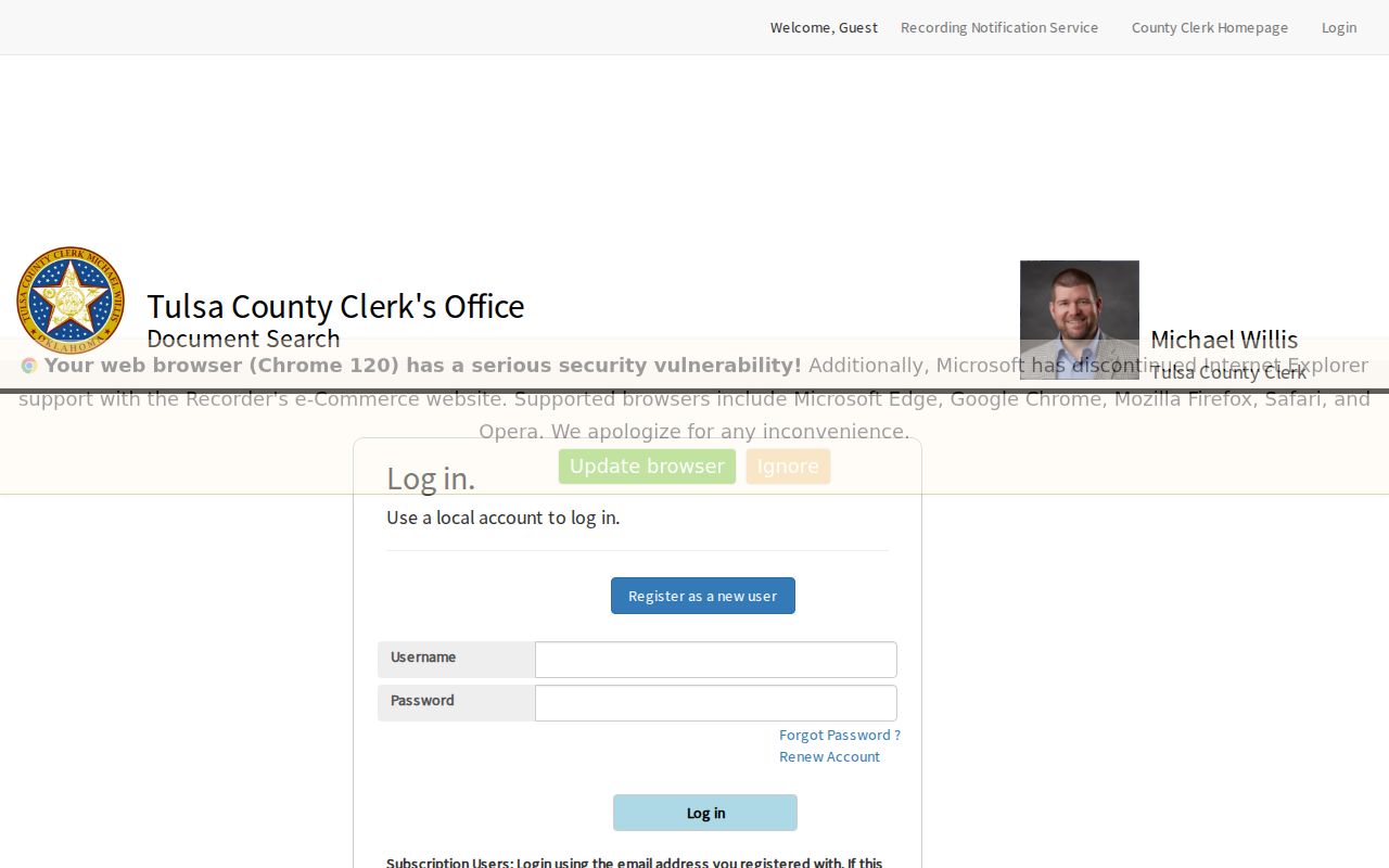
When the online index cannot supply the next deed, the Tulsa County Clerk is the office fallback. The land-record office is at 218 W 6th St, 7th floor, Tulsa, OK 74119, and its listed phone is 918-596-5801. Ask for an existing recorded instrument, historical index, camera image, deed book, or certified-copy procedure by parcel, legal description, document number, and date range. The screen image is not a certified deed and the online cutoff is not the start date of all county records.
Past Owasso Owners Through the Deed Chain
A chain of title follows recorded transfers backward. The assessor provides a current index clue and the sales-documents table can supply a sale date, grantor, grantee, deed type, and document number. The County Clerk is the statutory repository for the recorded conveyance. Keep the assessor warning in mind: its ownership field may not be current and is not a title opinion. A deed image or certified copy comes from the Clerk process.
- Confirm the county, then save the current assessor account, parcel, situs address, and legal description.
- Use the Acclaim parcel or allowed name route to locate the most recent recorded transfer.
- Record the grantee, grantor, recording date, deed type, and document number from the transfer.
- Search the seller as a prior grantee, then repeat the handoff one deed at a time.
- When the online index ends or access is gated, ask the relevant Clerk for historical books, indexes, camera material, or a certified-copy route.
- Grantor
- The party transferring an interest in the recorded instrument.
- Grantee
- The party receiving that interest in the recorded instrument.
- Chain of title
- The sequence of recorded transfers used to trace a parcel's conveyance history.
- Legal description
- The lot, block, subdivision, or survey description that stays more reliable than a changing street label.
Each handoff should retain the document number, source date, and the parcel or legal-description match. A recorded transfer can explain a conveyance without proving that either party occupied the address at that moment.
Owasso Previous Residents and Old Street Names
Owasso's original town-site plat was signed March 26, 1904. The first north-south streets were Oklahoma, Kansas, and Missouri, and eight east-west streets were named for Union and Confederate generals. City history says these original names changed around 1960. That change can make a valid older directory, deed, newspaper, or family paper look unrelated to the current address.
Search the old street name and the modern label as separate terms. Preserve av, st, directional abbreviations, r, and rms when they appear in historical material. The City Addressing Coordinator establishes lot numbers and street names, while newer curving streets and cul-de-sacs do not always behave like the original grid. A current address should never overwrite the source-era form in a research note.
Owasso Previous Residents in Directories and Census
Owners and past residents are not the same thing. A dated directory can place a printed name at an address, and an available census can add a household relationship and age context. TCCL's 1920 and 1921 Polk-Hoffhine volumes contain alphabetical and numerical street sections. The 1920 sample uses parentheses for a spouse where supplied, r for residence, rms for rooms or boarding, and b same for boarding at the same place. Those marks are historical shorthand, not current facts.
The TCCL 1920 directory sample shows the source's compact entry style.
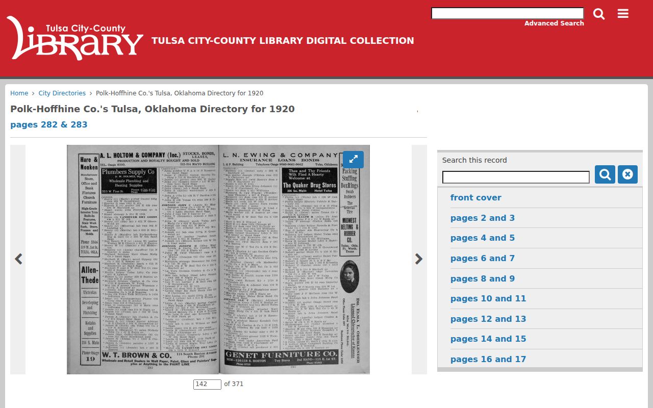
Pair the nearest directory years with the available census rather than trying to turn a single list into a full address history. The underlying shelves, editions, and abbreviation keys are described on the Owasso city directory page. A disappearance can mean a move, a different printed name, a coverage gap, an omission, or death, and needs another dated source before it is explained.
Owasso Address Events Between Residents
A house history gains context from more than deeds and directories. The City of Owasso publishes monthly permit listings and requires a certificate of occupancy for new construction, occupancy, or change-of-use events. The inspected city material states a $100 certificate fee and directs users to the GIS for city-limit verification. For an older file, request the specific permit or record by exact address and date range instead of assuming a monthly list is a complete archive.
Plats, easements, mortgages, tax-resale context, photographs, newspapers, maps, neighborhood records, and oral-history or manuscript material can each explain a dated change in the property story. Tulsa Historical Society research requests do not provide specific residential-structure histories. Its guidance instead points researchers toward TCCL's house, building, and neighborhood history material, property abstracts, the Preservation Commission, and the Architecture Foundation. Each item should be saved with its date and relationship to the structure.
Owasso Previous Residents Have Historical Gaps
Several gaps are known and should stay visible in an address report. A specific Owasso-year reverse or criss-cross directory was not located in the official sources. No Owasso-specific Sanborn map item was located in the official search. Rogers County's exact online land-record cutoff and search fields were not located. The older end of Acclaim's web coverage is a portal limit, not a statement that earlier recorded material is gone.
Birth records began filing in 1908 and became mandatory in 1917, with inconsistent pre-1940 coverage. The Owasso Ledger's observed digital run is only nine issues from 1904-1905, even though the title began in 1903. County formation details, first surviving books, record-loss events, and reconstruction projects also require custodian confirmation. These are reasons to document a gap and use office, library, microfilm, camera-image, or archive fallbacks rather than fill the gap with a guess.
Note: Record when an item was created, filed, indexed, digitized, last updated, and accessed, because those dates answer different questions about an Owasso address.
Owasso Previous Residents, Lawful Research
Past-resident work belongs in a limited, personal context such as family history, an estate or heir question, a property story, or civic history. It is not a reason to build a profile of a living person. A parcel card can show an owner index and mailing address, a neighborhood map can show a boundary, and a dated directory can show a printed entry. None alone proves who is present at an address now.
Lawful use. Use an Owasso address trail for careful historical or personal research. Do not use records to track, contact, stalk, harass, or harm a living person.
For a public record held by the city or county, request an existing record from the custodian under the Oklahoma Open Records Act, Title 51 O.S. §§24A.1-24A.31. A narrow request that names an address, date range, department, and document type is more workable than asking an office to create a new house history or compile everything about a property.